
It is often said that every part of Glasgow has been undermined at some time, and at some level, by mineral workings. In Linn Park these workings were numerous, early and shallow. The author’s guided walks, for the annual Scottish Geology Week and others, identified a deep interest in Linn’s landscape and minerals. Mineral working had a big impact on the land which makes up Linn Park.
The development of the parkland as a country estate only really took off once the minerals were worked out. In June 1813 the owner of Hagtonhill was still advertising:
‘a contract for turning out and burning from 12-15 hundred tons of limestone from that part of the lands of Linn immediately west of the farm of Linn. The limestone is in great abundance and easily wrought and the proprietor will either provide the coal or include it’.
The noise and bustle of a quarry, plus the smoke from the kilns would have dissuaded anybody who was seeking a country retreat.
Geology
 The rocks underlying the area are from the Carboniferous period around 300 million years ago, when sandstone, silts, coals and limestones were laid down on the fringes of a rising and falling sea. Occasional cracking and faulting allowed layers (intrusions) of volcanic rock (dolerite) to seep between strata. The volcanic rock has had a major impact on the landscape of Linn Park as it is much harder than the general sandstones and shales. The waterfall at Linn is made of a thick dolerite sill, and another dolerite intrusion forms the crag supporting Cathcart Castle.
 Sandstone is available throughout the area. Cathcart Castle itself was built from local sandstone which is still visible in its foundations. Before the availability of Giffnock sandstone, other local sources were important. Holeburn Quarry at Merrylee was the source of stone for Cathcart old kirk in 1831. The old tower still survives as an example of such early local sandstone.
The steep sides of the White Cart valley expose seams of coal between the sandstone and shales. The drop in level of the river over harder rocks created falls which powered a variety of mills. These mills needed coal for heating and boiling, and adverts usually noted the local availability of coal, thus mining and mills worked together. Some of the earliest references to the area which became Linn Park mention its minerals, and Hagtonhill seems to have been made a separate estate due to it mineral resources. In 1664 the Maxwells of Pollok obtained coal from Hagtonhill.
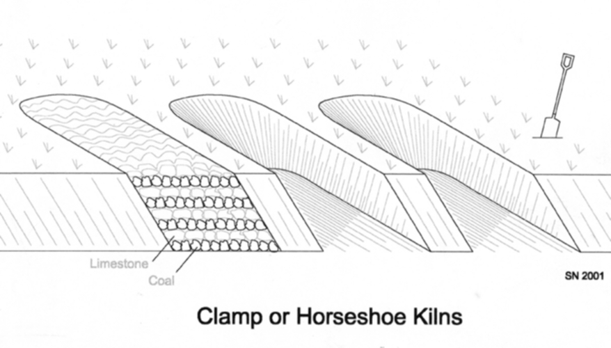 The local limestone is named the ‘Index’ limestone, because it usually indicated the presence of coal below it. Samples of this limestone can still be found, and it is a hard, grey mineral, similar to whin, but more brittle. Before the limestone could be used, it had to be burnt in kilns. Although there were large draw kilns in Cathcart, the most common type of early lime kiln was the clamp kiln, basically a horseshoe-shaped hollow in an earth bank. Layers of lime and fuel were built up, then covered with turf, then the fire was lit and left to burn for a few days, when the kilns were emptied and re-used.
Once burnt, limestone has many uses. One of its earliest applications was in building, as a cement or coating to rubble buildings. Cathcart lime was used in many early Glasgow buildings. Nowadays farming and mining are regarded as opposites, but in the 18th century large quantities of burnt lime were required for farming improvements. The benefits of agricultural liming were known and practised on a small scale from the 17th century. Widespread use of lime commenced from the mid 18th century. By the 1760’s, tenants in Cathcart Parish often had a deduction from their rents if they limed the land. This encouraged improvements, to the benefit of both tenant and landowner. Mining, quarrying and farming went hand in hand. It is no coincidence that the high point of lime and coal working in the area coincided with the peak in farming improvements.
The local working of limestone can be illustrated by an advert from 1764: “To let, the Lime Craig (Quarry) and Coal Pit and digging out as much coal as is necessary for burning the lime in the lands of Bogton, Cathcart”.
Limestone was the priority, and working of coal was restricted to what was required to burn the lime. An early mention of lime working in the area was on Bogton in 1599, when a lime craig (quarry), kiln and peat stack were in use. Gradually, as demand grew, coal provided a better fuel than peat. By the late 18th century the growing demand for lime had raised the local lime industry to the largest employer in Cathcart parish after farming. Six thousand carts of burnt lime were turned out each year, much of it for the improvement of local estates.
 There are five main coal seams below the Index Limestone, their local names being the Sclutty, Smithy, Main, Jewel and Geordies coals: the ‘Cathcart Coals’. These local coals were exploited from an early date from outcrops in the river valley. Unlike areas of deep mining, Linn Park still has evidence of exposures and old workings. This is why the area remains so interesting today. The thickness of the Cathcart Coals varies considerably, but the variety of seams meant that there were usually several of workable thickness at any location. The quality of the coals was also variable and was related to their use. Much of the coal was worked to fuel the local lime industry and lime burning did not require coal of high quality. It also served lime works further afield, particularly at Thorntonhall in East Kilbride Parish, where there were also numerous lime quarries and kilns.
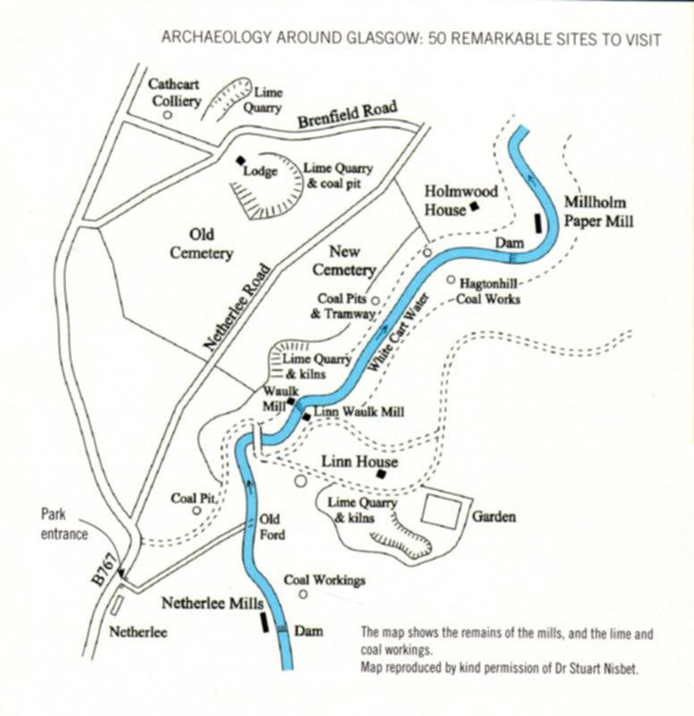 Descriptions for each of the old lands making up Linn follow. The map from ‘Archaeology Around Glasgow’ by Sue Hothersall (Glasgow Museums 2007) covers most of the park area. Walking in the park always requires a degree of common sense. Care is required near steep drops, or beside the river, and walkers should obviously avoid holes in the ground and never enter tunnels.
Castlemains
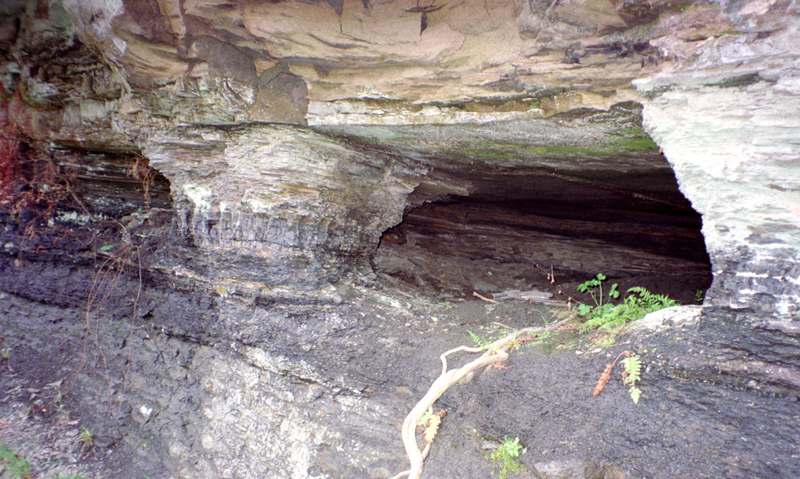 In the vicinity of Cathcart Castle whin was worked from the quarry on the side of Court Knowe. Coal workings were part of Cathcart deeds from the medieval period and are mentioned more specifically from the 1650’s. Along the riverside cliffs opposite Millholm, in winter when the trees are bare, old adits are evident in the steep banks and cliffs. Much of the area is unstable and for decades signs warned the public of the hazards.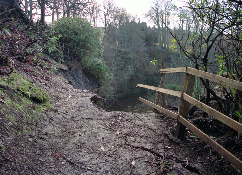
The old coal workings, plus gradual undermining by the river, contributed to the spectacular cliff collapse in March 1997, which took away one of the park’s paths and temporarily blocked the river. Some of the workings are more modern and during the depression of the 1920s unemployed miners worked coal from outcrops in the park and were chased by ‘parkies’.
Hagtonhill
The river banks above Millholm weir are the lowest accessible area on Hagtonhill estate and were the main focus of operations through the eighteenth century. Further pits stretch up through the woods towards Hagton Hill and the Top Wood. The riverside cliff From Millholm Weir up to Linn falls exposes much of the strata between the top of the Cathcart Coals and the Index Limestone. A thin coal outcrops below Linn falls.
As we reach Linn, the farm is split in two by a fault with a drop of about sixty metres. The slope of the hard whin sill which outcrops in the river, forming Linn falls gives a visible idea of the gentle dip of the rocks to the west.
Linn
An advert for Hagtonhill in 1766 included the coal and limestone quarries. The main Linn or Hagtonhill quarry was in the woods on both sides of the stables courtyard (Linn farmstead) including the ‘Millennium Wood’. The deep hollows here are man-made and there is a huge mound of spoil between the quarry and Linn gardens. Limestone quarrying and mining is recorded here for at least fifty years.
 Although pieces of burnt lime and slag were found scattered around, no lime kilns were known to have survived in the area until 1999. After clearance of rhodedendrons from the floor of the quarry, the writer identified a row of half a dozen clamp kilns, which were included in the interpretative signs. One of the kilns was excavated by Renfrewshire Local History Forum, with permission from the Council, in 2006. The excavation revealed burnt lime, a stone lining, and a flue. Contrary to interpretive signs in the park, the kilns were nothing to do with baking pots.
A local miner was killed in a roof fall in this quarry in January 1789:
‘Robert Mitchell, a labourer at Hagtonhill lime-quarry, was killed by a falling in of the roof of the quarry’. Sadly, deaths were fairly common, and in January 1822 ‘A man was killed in a coal pit at Cathcart - he has left a disconsolate widow and three children to lament his loss’.
In 1794 ‘good lime, House coal, Smithy coal and Lime coal’ were advertised at Linn. The working of this lime and coal was also to be let for a term of 3 years. By 1812 an advert for Hagtonhill included furnishing the tenant with agricultural lime during his first year ‘at a third of the price of East Kilbride lime’.
In 1806, parts of the lands of Hagtonhill and Bogton were advertised called the Linn Park, the Linn Land and Thornyfauld Park. Included were a good ‘post’ of Limestone and five seams of coal in the lands of Bogton. Offers were also made to build a bridge across the Cart for a good tenant.
The limestone outcrop continues across the Cart into the part of Linn Park in Bogton land. The tree-covered mound between the iron bridge and the wood is a typical man-made feature of estate improvements in the late eighteenth century. It seems too much of a coincidence that it lies on the line of the limestone outcrop, and may have been to conceal another working and fashioned from quarry spoil.
Bogton
If we cross the Ha’penny Bridge and turn left up the Lime Avenue to the Netherlee entrance of the park, we are in Bogton estate. The rubble wall to the side of Lime Avenue is the boundary with Netherlee Farm. Over the wall was Burnside Road which led down to the ford to Linn. In 1796 a young woman fell down a shaft here. Workers at Netherlee Bleachfield brought blankets, which they knotted together and lowered down to the girl. The men started hauling her up, but just as she reached the pit mouth, she lost her grip and fell back, this time to her death.
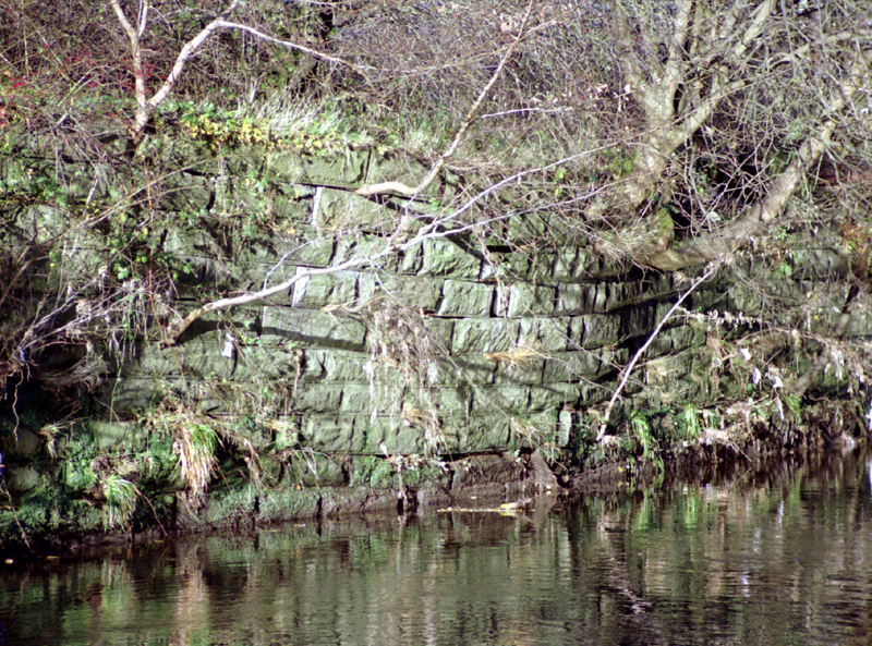 On either side of the park boundary between Bogton and Netherlee, the five Cathcart Coals, plus an additional local “Wee” coal, were worked from the 1600’s. In the fields to the side of Lime Avenue are several infilled coal pits. Further stone-lined coal pits and adits were uncover at Netherlee during building works in the 1980s. From the adits it was possible to walk into stoop and room workings a few metres below the ground. Building work halted for several years and travelling people moved onto the site. The site was latterly sold, and the ground was stabilised and developed. The riverside wall, built up at the old ford to Linn shows the effects of mining subsidence.
Back at the Ha’penny Bridge, the hollow beside the path up to the cemetery is a dolerite quarry. Just below the bridge, the Index Limestone crosses the Cart from Linn. Above the falls, the deep hollow heading for the cemetery is a lime quarry. Several more clamp kilns are hidden in the undergrowth. In 1782 this limestone was advertised, described as being of considerable thickness and ‘lying about half a mile above the village of Cathcart, and on the west bank of the water of Cart, at that part called the Linn’.
 Workings extend from Linn Falls under the cemetery towards New Cathcart. In the heart of the Old Cemetery is a deep quarry from where the limestone was followed deep into the hill. A drainage tunnel or ‘level’ was driven from here, falling gently eastwards, under the hill to Linn Falls, following the line of the limestone outcrop. David Allan, the forester at Linn, described this tunnel in 1881, saying: ‘The limestone used to be worked here opencast on both sides of the river, and at one time there was an "ingoing eye," or subway, driven from near the Linn waterfall to the workings behind New Cathcart’.
Workings continued along the outcrop beyond the cemetery to (Lime) Craig Road in three main quarries. As the quarries deepened, it became more convenient to mine the limestone from the quarry sides. In May 1785 a notice appeared that:
‘The tacksmen of the three lime craigs at Braehead and Bogton, Cathcart being agreed to sell no lime under 20 carts, but for ready money, and for 20 carts or upwards their employers will want credit and will favour them with a line for that purpose’.
Coal was also worked. In March 1770 an advert appeared for:
‘The coal in the lands of Bogton in Cathcart, two and a half miles from Glasgow, to be let for 30 years. There will be found four different seams of coal: The Soft (Sclutty) Coal is 3 feet thick, and then is found the Smiddy Coal 1’ 6” thick, known to be the best of its kind in the country, and then we find the Main Coal of 1’ 10” thick, and then the Splint (Jewel) Coal 1’ 6” thick. One of the shanks (shafts) above the level, is put down to the Splint Coal, ready to begin work’.
Apart from the limestone level at Linn Falls, the various mines in the Bogton area were drained by a second level, falling to the Cart on the downstream boundary of Millholm. In the 1790s the lime content of the water draining here from the coal and lime mines was described as having ‘the power of petrifying vegetable substances: pieces of wood and moss, completely converted into stone, have been picked up, bearing all the marks of their former texture and organization. Spars and crystallizations, of very curious form and appearance, have also been found’.
 By the Victorian period, coal was worked in the same area from New Cathcart Colliery, but at great depth. The much shallower limestone mines were forgotten. When news appeared in the 1990s that the site was to be developed, various protests were made regarding the loss of mature trees, but warnings about limestone workings were ignored. Building works had to be halted when the ground opened up, and the whole site had to be stabilised by grouting the limestone workings with cement through a network of tubes. As cement is a product of limestone, the voids were effectively refilled with lime.
Goldenlee
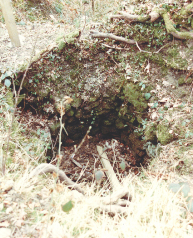 Along the riverbank in Goldenlee, from Linn falls to Millholm, coal to fuel the local lime kilns was worked from pits along the river bank in the park. In the 1980s, when a path was created through this area, several shafts were still open, and were investigated and filled in. However the observant walker will still see the circular stone-lined tops. An embankment for a tramway also rises up the slope to the cemetery.
Carrying on down the river, the Cathcart Coals outcrop in the river valley around Millholm weir. Some of the earliest workings were in this area. By the 1760's there were pits just above Millholm, towards Netherlee Road. Modern bores confirm that most of the coal in this area has been worked out and workings were stabilised before the building of flats in the area from the 1980s.
 Again the mills and minerals worked together. Millholm paper mill used the river to power its pulping and processing machines. However the river water was often too brown and silty to use for making white paper. Permission was granted by Gordon of Aikenhead (owner of Goldenlee) for ‘The right, privilege and liberty to convey the water from the old coal workings in my lands of Linn lying on the west bank of the River Cart for the use of the Paper Works at Millholm’. The cast iron pipe can still be seen running along the river bank. Another vertical pipe on the mill site still vents water and methane gas. The site of Millholm Paper Mill is fenced off and is not part of Linn Park.
Netherton
 South of Linn Park, the Cathcart Coals continue. At the Ramloch Burn, which separates Linn Farm from Netherton Farm on the estate of Castlemilk, there is evidence of working opposite the site of Netherlee printworks. Netherton takes in the wooded slopes of Netherton Braes all the way from Linn Cemetery to the Kittoch Water. The burrowings of foxes and other animals constantly exhume lumps of coal and fossils, confirming the shallowness of the seams. The rate of erosion by animals often exceeds other natural processes.
 The ruins of Netherton farmstead lie above the old ford across to the abandoned mining settlement of Mavisbank at Netherlee. Coal was worked here by the Williamwood Coal Company from the 1790’s. Maxwell of Williamwood formed a partnership with Lady Stuart of Castlemilk to work the coal on both sides of the river. This area, known as Bradiesholm, was a direct extension of Maxwell’s colliery across the river on Netherlee Farm. Above Bradiesholm the hillside is pockmarked by shallow adits and pits, some quite large, indicating the extraction of very shallow coals in an almost opencast fashion.
When we reach the hillside opposite Overlee Park, several old adits are evident in the steep braes below the ‘lost’ farm of Garsheugh. These operations date from the time of the original Overlee workings at the end of the 18th century. In 1911 a colliery was set up in Overlee Park to work this coal, but after considerable expense, the coal was found to have been previously worked, and the Overlee Colliery company went bankrupt.
Further West
The coal in the Linn and Netherton area generally dips (and deepens) towards the west. As shaft building and pumping technology gradually improved, the workings moved westwards, exploiting the deeper coals. By 1800 the Cathcart Coals were worked from shafts over 50 metres deep at New Cathcart, then at depths approaching 100 metres at Bogton Bog, on the extreme western side of Cathcart Parish, on Bogton Bog (Braidholm sports ground), where limestone was also mined. In the early 20th century the same coal was worked even deeper, under much of Giffnock, from pits near Burnside Road, Giffnock.
The above notes on minerals in the Linn Park area are extracted from ‘Coal from Clarkston to Cathcart’ (1999) by Stuart Nisbet.
Previous Article: Linn Mills